
Signs of Hope
After Years of Effort, Coho Salmon Numbers are Up in the Navarro River
by Torrey Douglass
According to local legend, there was a time when fishermen would stand shoulder to shoulder along the banks of the Navarro River, catching fish after gigantic fish as coho salmon made their way upstream from the sea. The take-home haul could number 40 salmon apiece back then. By the 1970s, it might take a full day of fishing to catch just one. What happened to land the coho—at least the type that lives along the Mendocino coast—on the endangered species list?
Coho need clear, cool water. If the river is running high and not clogged with fine sediments, the redds (nests of fish eggs in the gravel bed of a stream or river) can get the oxygen they need. If sediment settles out of the river current into the gravel, it turns the river’s bottom into a cement-like sludge, smothering the redds and their eggs in the process. And if the river flow is low during summer, the water temperature gets too high for the juvenile salmon to survive.
The Navarro River is one of the rivers that’s seen coho popula- tions almost disappear over the last 75 years. It flows through Anderson Valley, a region that historically had large stretches of mature redwood forests. Logging started in those forests once settlers arrived in the 1850s, then accelerated after the San Francisco earthquake of 1906 when Mendocino County timber was used to rebuild the city. Cut trees were brought to one of the mills in Anderson Valley—at one point as many as 36—including one south of the town of Navarro. There it was processed into lumber, then loaded onto a train that followed Flynn Creek out to the coast. Ships waited off Albion to carry the lumber to San Francisco.
Logging trees right up to the river’s edge removed canopy cover and also loosened soils along the banks, which would end up in the currents once the winter rains arrived. Techno- logical advancements developed during WWII supercharged tree removal, allowing bulldozers and other large machines deeper into the forests, driving up summer-dry streambeds and leaving skid trails along the upper slopes.
As lumberjacks and other settlers moved into Anderson Valley, they built roads into the hills. These days, best practices for rural road engineering make them “hydrologically invisible,” meaning they minimize sediment in the runoff flowing into creeks and rivers. But that was not always the case. To under- stand the impact of road design, imagine an undeveloped hillside sloping down to a stream. During rainfall, the water flows slowly through a living skin of organic leaf litter, fungi, and intact forest root systems. When the water is spread and slowed, more will sink into the soil. But after a road is sliced across the slope, those flows are interrupted. All of that water is channeled in one direction, usually into a pipe or culvert that passes under the road. If the culvert isn’t big enough, a big storm can cause the water to back up, increasing the speed and pressure of the flow. Sometimes it floods over the road, picking up more loose dirt and debris on its way to the river.
When water that used to meander down an incline is suddenly shoved into a single channel feeding a too-small pipe, the escaping water coming out the other side turns into a sort of firehose, washing away whatever is in its path. The powerful water delivers sediment to the waterway directly and indirectly, eroding the soils it passes over and digging deep ravines into the landscape.
As the bottom of a ravine sinks further into the earth, the water table drops, too. Just like water in a bucket with holes, a water table will sink to the lowest point where its water can escape. Any land above that point dries out like a sponge left in the sun. The drier conditions absorb less rainfall, cause erosion-preventing vegetation to die back, reduce summer stream flows, and can leave wells high and dry.
The U.S. Geological Survey installed a gauge on the Navarro River in 1950. The biggest storm it has measured since came in 1955, washing away vast amounts of sediment loosened by legacy logging practices. After another storm in 1965 caused more serious flooding, coho numbers began to decline steeply. But the collapse did not truly arrive until the drought of ‘76 and ‘77, decimating already flagging popula- tions and shrinking the local fishing industry considerably.
Some local fisheries held on until the 90s, until runs were so sparse that they, too, had to close. By 1996 the coho off the Central California Coast were declared threatened under the Endangered Species Act, then reclassified as endangered in 2005. That same year Linda MacElwee was hired by the Mendocino County Resource Conservation District (MCRCD) as their Education and Outreach Coordinator, later taking on the role of Watershed Coordinator. Through her work, Linda educates people about the river and its impact on local ecology, and also oversees projects designed to support the return of coho in the Navarro.
“Coho is an indicator species,” Linda shares. “When they are doing well, you know the watershed is healthy.” Improving the river conditions to help coho salmon populations recover necessitates a mix of strategies. In July of 2000, Califor- nia’s Board of Forestry adopted “Threatened or Impaired Watershed Rules” that prevented logging directly along a riverbank. Instead, a “riparian buffer” preserves a stretch of trees along the waterway, stabilizing soils, providing shade, and reducing temperatures.
MCRCD, Trout Unlimited, The Nature Conservancy, and California Conservation Corps have worked hard to improve habitat for coho. The California Department of Fish and Wildlife, Wildlife Conservation Board and National Oceanic and Atmospheric Administration/National Marine Fisheries
(NOAA/NMFS) and CA Department of Water Resources, among others, provided funding for the work. Some projects installed fallen trees into the river at an angle, with one end stuck into the riverbed and the rest leaning against the bank. Heavy winter rains carve deep, cool summertime pools behind these logs where juvenile salmon can find safe refuge, and also sort gravels to create ideal spawning beds.
Other projects funded water storage solutions for landowners. In exchange for large tanks that can store the amount of water needed through the dry season, the landowner agrees to refrain from pumping water from July through October, allowing water to remain instream for habitat and fish. For example, with grant funding, Blue Meadow Farm in Anderson Valley installed two tanks that together can hold 100,000 gallons—a combination of rainwater catchment and off-stream storage—so they don’t have to draw that water from the stream during the low-flow months. This increases the farm’s water security while improving habitat for fish and other wildlife.
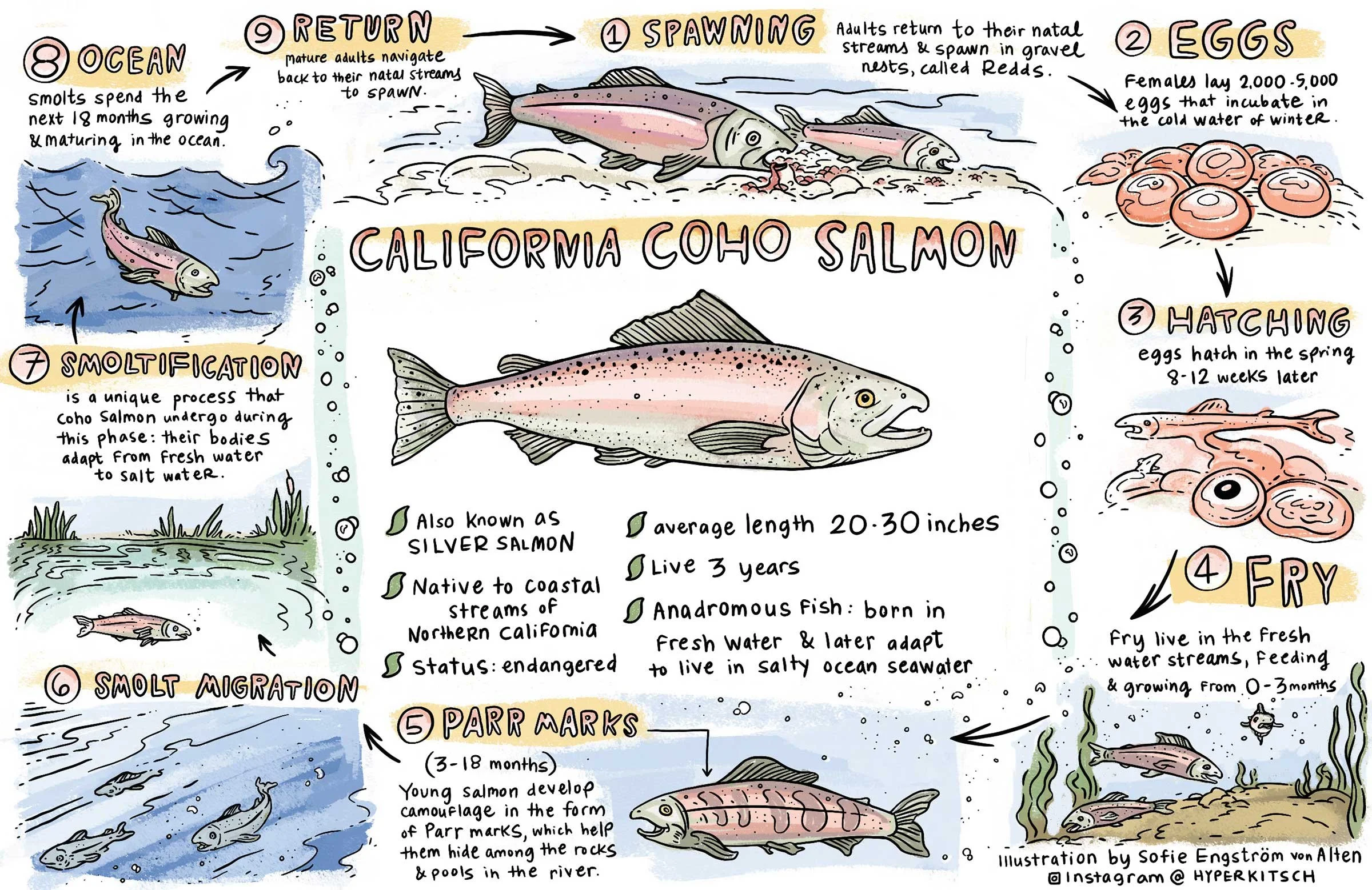
The Navarro is also home to steelhead trout, whose populations have diminished to the point of being listed as a federally threatened species. Steelhead can withstand higher temperatures and make multiple trips to and from the sea. They also live longer than coho, giving them more chances to reproduce. In contrast, coho have a fairly strict 3-year lifespan, with only one reproductive opportunity. They lay their eggs in the cold water of winter, which hatch 8 to 12 weeks later. The babies (fry) spend about 18 months in the river before they migrate downstream during their second spring. While lingering in the estuary’s brackish waters, the juveniles transform from freshwater fish to saltwater. This process, known as smoltification, changes the salmon’s body shape, increases the reflective capacity of their skin, and adjusts their gills so they can breathe in the ocean, where they spend the next 18 months.
During their third winter, the now-adult coho are ready to spawn. Between November and February, depending on the rains, they reverse the migration, traveling back up the river to the same spot where they hatched. A female uses the side of her body to dig a shallow depression into the gravel, then lays her eggs in it. The male of her choice—usually the largest—fertilizes the eggs. Younger males who’ve joined the migration a year early linger on the periphery, looking for a chance to sneak in and do some fertilizing of their own. Biological imperative accomplished, all the fish die within two weeks, becoming food for forest animals and adding valuable nutrients back into the watershed.
By categorizing coho salmon as endangered, the state of California and the National Marine Fisheries Service hope to support the species’ recovery before a bottleneck of genetics causes its extinction. Ongoing monitoring of winter migra- tions showed the coho continuing to struggle throughout the 2010s, with zero adult fish observed during the 2014 spawning season. That year the sand bar that blocks the mouth of the Navarro River for part of each year didn’t shift in time to allow the spawning fish through.
The tides finally changed during the 2023-2024 season, when a spike in populations was observed in other Mendocino Coast waterways, including the Noyo, Garcia, and Ten Mile rivers. A total of 15,000 adult fish were counted along the Mendocino Coast, but only 260 of those came up the Navarro. The following season, however, that number increased more than tenfold, with 2800 adult fish counted in the Navarro River during the 2024-2025 migration. Some were seen in places they have not been spotted for decades, like upper Rancheria and Anderson Creek sub-basins.
While this news is decidedly heartening, the crisis for coho is not over. In order to be removed from the endangered species list, 5700 adults need to be counted in the Navarro alone. Linda is cautiously optimistic, saying, “It’s time to do more work, faster. The fish are resilient, but we need to be ready for the next drought cycle.” Measures like improving road design and forestry practices, building in-stream habitat, and supporting landowners with water storage have all helped. Unrelated trends, like the reduction in illegal cannabis grows, have helped, too. Often unpermitted grows would pull water from springs, creeks, and river-adjacent wells, while legal grows today are required to be off-stream.
Living in a watershed connects all who live there. One of the things that builds hope and promise for the Navarro is having a community that loves where they live and wants to best steward its natural resources. As the saying goes, it takes a village to restore a watershed. There are opportunities for everyone to conserve, protect and restore the natural processes that support a healthy and vibrant river system for humans and creatures alike.
For more information about restoration efforts for the Navarro River, go to mcrcd.org/resources/flow-enhancement and navarroriver.org. A free copy of Navarro River Guide to Watershed Care and Restoration, a map of the Navarro watershed, and Handbook for Forest, Ranch and Rural Roads can be downloaded at mcrcd.org/resources/publications.
Illustration by Sofie Engstrom von Alten of HyperKitsch (hyperkitsch.com). Coho photo by Bureau of Land Management Oregon and Washington, Public domain, via Wikimedia Commons.